Those weird Dutchies!
1/12/11 14:29The Benelux region is home to some of the strangest occurrences on Earth. Want proof? Well, have a look at this!
I give you the amazing labyrinth of Baarle-Hertog and Baarle-Nassau, two provinces of Belgium and The Netherlands, respectively. Are you noticing something strange there? Not yet? OK, look closer...

The Netherlands is shown in orange (but of course!) And Belgium is shown in green. Below is a closer image of the border:

This border was established as part of the Treaty of Maastricht (1843). In the Baarle area (see the "B" letter on the above map) they had enormous difficulties with reaching an agreement about the border. So instead of a permanent border, several thousand plots of land were assigned their jurisdiction on a case-by-case basis. Some of these plots are now forming up to 20 Belgian exclaves (part of the Baarle-Hertog province) located well within the Dutch province of Baarle-Nassau and situated about 5 km away from the Belgian "mainland":

See even closer map:

Conversely, the orange parts situated within the Belgian territory are actual exclaves of the Netherlands completely surrounded by Belgian territory which are in turn completely surrounded by the territory of the Netherlands (OMG, my head is gunna assplode now!!!) The even funnier thing is that technically, the border runs right through the middle of some houses!

...And through some sidewalks, even cafeteria.

...And through supermarkets.

So what happens inside the buildings that are finding themselves split by this border? Some guys have turned their houses into tourist attractions, one even split his bedroom right through the middle, half of the bed and part of the furniture being in The Netherlands and the other in Belgium (his wife obviously sleeps on Belgian territory)...
There's also this trick: if the taxes at one side of the border are more favorable this year, the owner of such a house would put their main entrance on, say, Dutch territory. But next year nothing prevents them from moving the entrance on Belgian territory, at the opposite side of the house! It's crazy.
Extra read on the subject:
An Historical and Documentary Study of the Belgian and Dutch Enclaves of Baarle-Hertog and Baarle-Nassau, Brendan Whyte
Enclaves of Baarle, from: Brekelmans, F.A.. De Belgische enclaves in Nederland. Tilburg, 1965
Map of Baarle: Blue = Baarle-Hertog; Red = enclaves of Baarle-Nassau; white = main body Baarle-Nassau.
The Low Countries 1556-1648
A 1962 military map of Baarle
The Village of Baarle
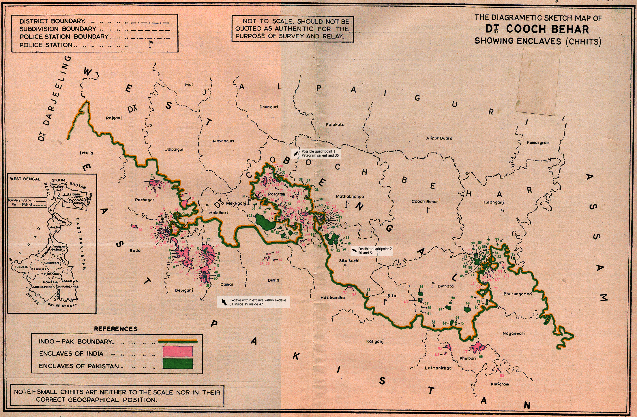
The Exclaves, Counter-Exclaves and Counter-Counter-Exclaves in Cooch-Behar (courtesy of Brendan Whyte)
An Historical and Documentary Study of the Cooch Behar enclaves of India and Bangladesh, Brendan Whyte
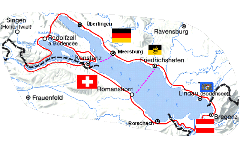
Lake Constance: A Mereotopological Black Hole in the Heart of Europe
International Exclaves & Enclaves
Hidden Europe 3: Tangled Territories
I give you the amazing labyrinth of Baarle-Hertog and Baarle-Nassau, two provinces of Belgium and The Netherlands, respectively. Are you noticing something strange there? Not yet? OK, look closer...
The Netherlands is shown in orange (but of course!) And Belgium is shown in green. Below is a closer image of the border:
This border was established as part of the Treaty of Maastricht (1843). In the Baarle area (see the "B" letter on the above map) they had enormous difficulties with reaching an agreement about the border. So instead of a permanent border, several thousand plots of land were assigned their jurisdiction on a case-by-case basis. Some of these plots are now forming up to 20 Belgian exclaves (part of the Baarle-Hertog province) located well within the Dutch province of Baarle-Nassau and situated about 5 km away from the Belgian "mainland":
See even closer map:
Conversely, the orange parts situated within the Belgian territory are actual exclaves of the Netherlands completely surrounded by Belgian territory which are in turn completely surrounded by the territory of the Netherlands (OMG, my head is gunna assplode now!!!) The even funnier thing is that technically, the border runs right through the middle of some houses!
...And through some sidewalks, even cafeteria.
...And through supermarkets.
So what happens inside the buildings that are finding themselves split by this border? Some guys have turned their houses into tourist attractions, one even split his bedroom right through the middle, half of the bed and part of the furniture being in The Netherlands and the other in Belgium (his wife obviously sleeps on Belgian territory)...
There's also this trick: if the taxes at one side of the border are more favorable this year, the owner of such a house would put their main entrance on, say, Dutch territory. But next year nothing prevents them from moving the entrance on Belgian territory, at the opposite side of the house! It's crazy.
Extra read on the subject:
An Historical and Documentary Study of the Belgian and Dutch Enclaves of Baarle-Hertog and Baarle-Nassau, Brendan Whyte
Enclaves of Baarle, from: Brekelmans, F.A.. De Belgische enclaves in Nederland. Tilburg, 1965
Map of Baarle: Blue = Baarle-Hertog; Red = enclaves of Baarle-Nassau; white = main body Baarle-Nassau.
The Low Countries 1556-1648
A 1962 military map of Baarle
The Village of Baarle
The Exclaves, Counter-Exclaves and Counter-Counter-Exclaves in Cooch-Behar (courtesy of Brendan Whyte)
An Historical and Documentary Study of the Cooch Behar enclaves of India and Bangladesh, Brendan Whyte
Lake Constance: A Mereotopological Black Hole in the Heart of Europe
International Exclaves & Enclaves
Hidden Europe 3: Tangled Territories
(no subject)
Date: 1/12/11 12:46 (UTC)(no subject)
From:(no subject)
From:(no subject)
From:(no subject)
From:(no subject)
From:(no subject)
From:(no subject)
From:(no subject)
From:(no subject)
From:(no subject)
From:(no subject)
From:(no subject)
From:(no subject)
Date: 1/12/11 12:50 (UTC)(no subject)
Date: 1/12/11 13:02 (UTC)(no subject)
Date: 1/12/11 13:07 (UTC)(no subject)
Date: 1/12/11 13:09 (UTC)(no subject)
From:(no subject)
From:(no subject)
From:(no subject)
From:(no subject)
From:(no subject)
From:(no subject)
From:(no subject)
From:This from a man who champions offal….
From:Re: This from a man who champions offal….
From:Re: This from a man who champions offal….
From:Re: This from a man who champions offal….
From:(no subject)
From:(no subject)
From:(no subject)
From:(no subject)
From:(no subject)
From:(no subject)
Date: 1/12/11 13:14 (UTC)(no subject)
From:(no subject)
Date: 1/12/11 13:15 (UTC)(no subject)
Date: 1/12/11 13:18 (UTC)(no subject)
Date: 1/12/11 13:23 (UTC)(no subject)
Date: 1/12/11 14:30 (UTC)(no subject)
Date: 1/12/11 15:59 (UTC)(no subject)
Date: 1/12/11 16:34 (UTC)(no subject)
Date: 2/12/11 04:37 (UTC)(no subject)
Date: 1/12/11 16:54 (UTC)(no subject)
Date: 1/12/11 18:03 (UTC)(no subject)
Date: 1/12/11 18:54 (UTC)(no subject)
From:(no subject)
Date: 1/12/11 19:10 (UTC)(no subject)
Date: 1/12/11 19:20 (UTC)DUDE, WTF!?!?
And his name is... his name is "Di Rupo"!
SERIOUSLY.
(no subject)
Date: 1/12/11 19:22 (UTC)(no subject)
From:(no subject)
From:(no subject)
From:(no subject)
From:(no subject)
From:(no subject)
From:(no subject)
Date: 1/12/11 19:22 (UTC)(no subject)
Date: 2/12/11 04:35 (UTC)The USA/Canada western border was eventually decided along the 49th after the 54/40 fight. The 49th is a straight straight straight line. This cuts off Point Roberts in Washington State from the rest of continental USA. The only way to drive from Blaine Washington to Point Roberts Washington is through Canada.
That same 49th parallel straight line cuts through farms, barns, houses and even towns. It's mostly settled now with over a century to get used to it. But even quite recently ithas been nasty and complicated....
http://www.boston.com/news/local/vermont/articles/2010/05/17/vt_farmer_draws_a_line_at_us_bid_to_bolster_border/
(no subject)
Date: 4/12/11 11:28 (UTC)